- This website reflects our views on the Terminal 5 site based on many years of post-excavation analysis, which culminated in the publication of the final volume of the T5 report in 2010.
The Heathrow Landscape
How do we know this?
Find out more details in our archaeological evidence sectionHeathrow Airport
The Archaeologists
Framework Archaeology
Author Archives: admin
An Enclosed Landscape
Explore the Enclosed Landscape
In the period between 2,000 BC and 1,000 BC the monumental Neolithic landscape was transformed to of one of agricultural production set within fields enclosed by boundaries marked by ditches, banks and hedges. Within the fields the Bronze Age inhabitants dug waterholes for their domesticated cattle and sheep and built small settlements that were approached by trackways running between fields and animal pens.
This pattern of fields and hamlets continued to develop throughout the Bronze Age, and the shape of the rural landscape of Heathrow at about 1000 BC would be somewhat familiar to us today. The development of an enclosed landscape containing settlements suggests that there was a major social and economic revolution in the way that ownership and access to resources linked the people and the land. The land and the communities became linked by ownership
Posted in The Enclosed Landscape
Leave a comment
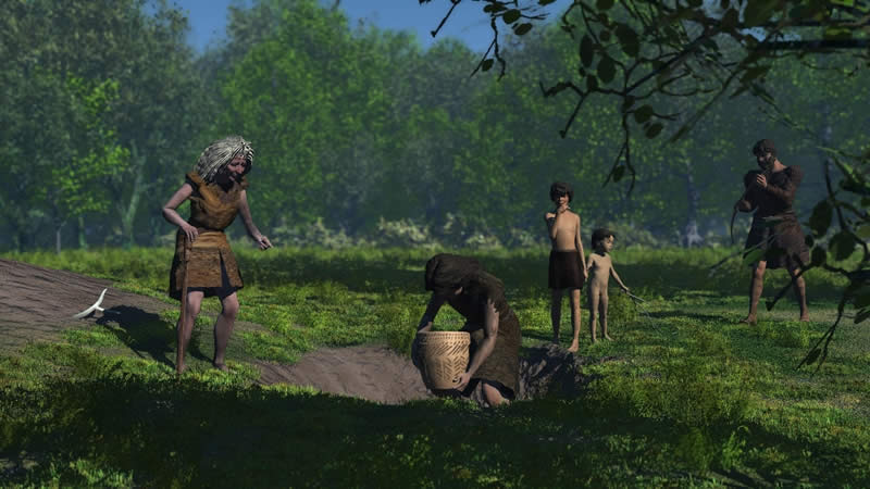
4,200-3,600 BC A Clearing in the Woods

People working to extend a clearing in the woods, during the Neolithic
Neolithic Clearance
The introduction of agriculture around 4,000 BC seems to have little impact on the landscape, at least at first. However, around 3,700 BC the combination of human activity and Dutch Elm Disease led to a dramatic decline in the proportion of elm trees in the forest. It is likely that disease would lead to the opportunity for people to clear patches of dead or non-viable elms. The labour required for cutting down and uprooting mature trees is considerable, and this opportunity to create clearances in the forest would have required the different family groups to come together and co-operate on a formal basis. This act of labour would have strengthened the bonds between the families, and led over time to the creation of clearings for more extensive grazing of domesticated animals and the growing of crops. How the families responded to the opportunity presented by the elm decline had a direct effect on the landscape, but also the indirect effect of starting to build a stronger community. From now on, the family groups had to negotiate who, how and where they would exploit not only the natural resources of the landscape, but also the important clearings that they had created. One of the mechanisms they employed to do this was to elaborate the oral and ritual traditions of the past into ceremonies, and then to place those ceremonies within an architectural context. For instance, at two locations along the edge of the Colne floodplain were a series of timber posts, which may have functioned as totem poles. It is likely that each family group had a particular location or locations which were historically important to them, such as the Mesolithic bunt flint pits, where they hosted meetings and ceremonies for the leading members of the other family groups. It is possible that the ceremonies involved processing from place to place, and just such a route way seems to have linked the string of small monuments and settlements along the edge of the Colne floodplain. The remains of one possible settlement were found under the alignment of the later Stanwell Cursus at Heathrow.
The Urban Hinterland
From 100 BC the people of southern Britain came into increasing contact with the Roman Empire culminating in 43AD with the Roman invasion of Britain. For the next 370 years Britain became tied into the politic and economic structure of the Roman Empire.
One of the biggest impacts in the South East was the foundation of the city of Roman London (Londinium) and the network of roads and roadside towns that spread out from the capital. The Heathrow landscape now became part of an urban hinterland supplying agricultural produce and raw materials to the city and towns.
The Heathrow landscape was now part of a much larger and complex network, though links with earlier periods are also clear. The political power centres were now relocated to the urban centres, ultimately to Rome itself. Their influence spread along the networks of roads and changed the nature of land ownership, rental and taxation.
The orientation of the Iron Age buildings and enclosures was maintained in the construction of further enclosures, paddocks and buildings during the Roman period. These cut across the line of the Bronze Age field system and represent the first reorientation of access routes and enclosures for some one and a half millennia.
This reorganisation of the landscape seems to conform to the orientation of roads track-ways and enclosures in the west London area. Though we must assume that the earlier banks and hedges had been removed, the practice of deliberate deposition of artefacts seems to remain. A complete pot was discovered in the bottom of one waterhole and in another a large part of a lead tank or font was found.
The people undoubtedly witnessed a great deal of social and political change. New rectangular buildings, some with multiple rooms indicate a change in both building skills and the organisation of homes and farms. It is clear that though that these changes were occurring in a landscape which still held important traditional values.
Posted in The Urban Hinterland
Leave a comment
3,600-3,300 BC Dividing the Landscape: the Stanwell Cursus
![]() Download an animation showing how the cursus might have been built in sections (requires QuickTime).
Download an animation showing how the cursus might have been built in sections (requires QuickTime).
![]()
Monument construction
Sometime between c. 3,600 and 3,300 BC, the small monuments and settlements gave way to a sequence of much larger and visually impressive earthwork monuments. The earliest of these may well have been a small “horseshoe shaped” earthwork enclosure (HE1), the entrance of which was aligned with sunset at the mid-winter solstice, as well as a potentially earlier group of timber posts. We can imagine the “horseshoe” monument holding a small group of people, perhaps the community leaders, who gathered together at mid-winter to hold ceremonies that involved solar observations. The material from the enclosure ditches suggests that the rest of the community may have taken part in feasting outside the enclosure. We can thus see how the community evolved the mechanisms for agreeing control and access to the landscape and its resources through increasingly elaborate ceremonies and architecture.

![]() Download an animation that shows people observing the winter solstice sunrise from the horseshoe enclosure, and the bank of the cursus (1.4MB, requires QuickTime).
Download an animation that shows people observing the winter solstice sunrise from the horseshoe enclosure, and the bank of the cursus (1.4MB, requires QuickTime).
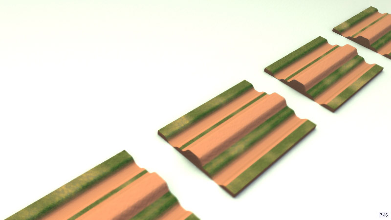
The ultimate expression of this architecture was in a series of huge linear cursus monuments, the largest, though not necessarily earliest, of which was the Stanwell Cursus. This remarkable monument ran in an almost straight line for 3 kilometres from the River Colne in the northwest to the edge of the Taplow gravel terrace beneath Stanwell in the southeast. It consisted of two parallel ditches, the earth from which was used to build a single central bank.
The monument appears to have been set out very precisely so that it linked together and buried a line of earlier important locations such as the burnt flint pits, posthole groups and settlements. It was built as a series of sections, each c. 150 to 200 metres long, and each section could have been built by four people working for 16 to 20 weeks, perhaps by particular family groups associated with the earlier location or monument that lay beneath the cursus. The construction of the cursus fulfilled many roles, but perhaps its most important legacy was that it affirmed through the construction of a communal project and through communal labour the pre-eminence of a community consisting of component families.
The architectural impact of such a monument would have been immense, but the social implications would have been even more far-reaching. The Stanwell cursus now served as a stage for the leaders of the community to process along and undertake ceremonies at the places along its course, which still remained sacred to the family groups. Underlying these ceremonies was a need to negotiate and agree access to land and resources in an increasingly cleared landscape. Thus the community had made itself and set itself upon a new course of social interaction that also included the construction of three other cursus monuments (referred to as the C2, C3 and C4 cursus), smaller in length though occasionally much greater in width.
3,600-3,300 BC Cursus Landscape animation
![]() Download an animation showing the cursus (requires QuickTime).
Download an animation showing the cursus (requires QuickTime).
3,300-2,600 BC From Linear to Circular: Changing the Use of Space
![]() Download an animation that shows people observing the winter solstice sunrise from the horseshoe enclosure, and the bank of the cursus (1.4MB, requires QuickTime).
Download an animation that shows people observing the winter solstice sunrise from the horseshoe enclosure, and the bank of the cursus (1.4MB, requires QuickTime).
From Linear to Circular: Changing the use of space
In the later Neolithic, the type and nature of monuments changed, through a transformation from linear to circular space. This change may be linked to shifting conceptions concerning land, space, and social and community relations. For example, a small circular earthwork enclosure was constructed within the C2 cursus. The entrance of this “horseshoe shaped” enclosure was aligned with sunset at the mid-winter solstice. We can imagine the “horseshoe” monument holding a small group of people, perhaps the community leaders, who gathered together at mid-winter to hold ceremonies that involved solar observations. The material from the enclosure ditches suggests that the rest of the community may have taken part in feasting outside the enclosure. We can thus see how the community evolved the mechanisms for agreeing control and access to the landscape and its resources through increasingly elaborate ceremonies and architecture. Other small circular henge-like monuments with external banks were constructed at other key locations within the landscape. The circular monuments imply that meeting places had now become more formalised, structured and perhaps more proscriptive, underlying fundamental changes within the society as a whole.
Posted in The Monumental Landscape
Tagged animation, cursus, monuments, neolithic, solstice
Leave a comment