- This website reflects our views on the Terminal 5 site based on many years of post-excavation analysis, which culminated in the publication of the final volume of the T5 report in 2010.
The Heathrow Landscape
How do we know this?
Find out more details in our archaeological evidence sectionHeathrow Airport
The Archaeologists
Framework Archaeology
Category Archives: The Urban Hinterland
100 BC-400 AD A New Direction

Roman settlement and landscape.
From 100 BC (Late Iron Age) the people of southern Britain came into increasing contact with the Roman Empire, culminating in AD 43 with the Roman invasion of Britain. For the next 370 years Britain became tied into the political and economic structure of the Roman Empire. At Heathrow, the old Middle Iron Age settlement became a focal point for continuing occupation through into the later Iron Age and early Roman period, although parts of the landscape were radically altered at this time, with new alignments of field systems largely overwriting the previous land divisions. While animal husbandry remained a fundamental part of the agricultural economy, the evidence suggests an increasing emphasis on cereal crops from the Late Iron Age onwards. The settlement complex appears to have been continually modified on a somewhat ad hoc basis throughout the Roman period, and would have undoubtedly become an integral part of the emerging Roman economy, with trackways being cut across the ancient landscape to serve the new markets at nearby Staines and the growing city of Londinium.
During the later Roman period (from the 3rd century AD) radically new styles of structure and wholesale changes to the eastern field systems were introduced, resulting in a substantial ‘ladder’ enclosure system, surrounding a major central droveway, designed to accommodate high levels of livestock traffic. The impetus for such development was probably commercial, perhaps driven by wealthy estate owners to maximise profits in a steadily changing economic environment. Farms like the one at Terminal 5 may have been incorporated into large managed agricultural estates (latifundia), perhaps belonging to the owners of more remote villas and/or wealthy townhouses in London. Rural farmers on these estates may have become coloni, essentially subsistence workers who were tied to the land in service of the estate, though also able to produce a meagre surplus for themselves.
400 AD The End of an Era
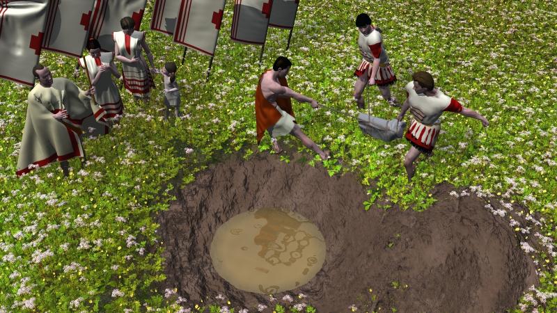
A lead font is submerged in a waterhole
It cannot be demonstrated that occupation continued at Terminal 5 beyond the later 4th century AD, but it was probably at this time (c AD 400) that the inhabitants of the farmstead deposited the remains of a damaged lead tank into a waterhole on the floodplain to the west of the main settlement. The tank is one of a small group of Roman Christian lead tanks found only in Britain, possibly used for baptism or washing of the feet and indicates a small Christian population at the site. The placing of this object within a waterhole, perhaps especially dug for the occasion, is, nevertheless, part of a long-standing tradition of ritual deposition within watery contexts. It suggests that Christianity had absorbed aspects of earlier spiritual traditions, possibly helping the occupants to deal with the tumultuous shifts in the religious, political and social circumstances of the final days of the Roman Empire in Britain.
The Urban Hinterland
From 100 BC the people of southern Britain came into increasing contact with the Roman Empire culminating in 43AD with the Roman invasion of Britain. For the next 370 years Britain became tied into the politic and economic structure of the Roman Empire.
One of the biggest impacts in the South East was the foundation of the city of Roman London (Londinium) and the network of roads and roadside towns that spread out from the capital. The Heathrow landscape now became part of an urban hinterland supplying agricultural produce and raw materials to the city and towns.
The Heathrow landscape was now part of a much larger and complex network, though links with earlier periods are also clear. The political power centres were now relocated to the urban centres, ultimately to Rome itself. Their influence spread along the networks of roads and changed the nature of land ownership, rental and taxation.
The orientation of the Iron Age buildings and enclosures was maintained in the construction of further enclosures, paddocks and buildings during the Roman period. These cut across the line of the Bronze Age field system and represent the first reorientation of access routes and enclosures for some one and a half millennia.
This reorganisation of the landscape seems to conform to the orientation of roads track-ways and enclosures in the west London area. Though we must assume that the earlier banks and hedges had been removed, the practice of deliberate deposition of artefacts seems to remain. A complete pot was discovered in the bottom of one waterhole and in another a large part of a lead tank or font was found.
The people undoubtedly witnessed a great deal of social and political change. New rectangular buildings, some with multiple rooms indicate a change in both building skills and the organisation of homes and farms. It is clear that though that these changes were occurring in a landscape which still held important traditional values.
Posted in The Urban Hinterland
Leave a comment