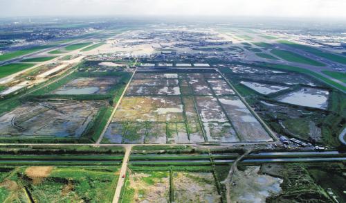
- This website reflects our views on the Terminal 5 site based on many years of post-excavation analysis, which culminated in the publication of the final volume of the T5 report in 2010.
The Heathrow Landscape
How do we know this?
Find out more details in our archaeological evidence sectionHeathrow Airport
The Archaeologists
Framework Archaeology
Author Archives: admin
Final Heathrow Terminal 5 Book Launched
 The second and final volume on the excavations at Heathrow Terminal 5 was launched yesterday at The Royal Society, London. Guests from Heathrow, who run Heathrow Airport, and the heritage sector gathered to celebrate the successful conclusion of one the biggest and most innovative archaeological projects ever undertaken in the UK.
Over 70 hectares were excavated in advance of the new terminal by an Oxford Wessex Archaeology joint venture ‘Framework Archaeology.’ Key parts of the project were an explicitly research-led approach and new high-tech ways of working. The project was awarded the 2008 British Archaeological Award for Best Project.
Speaking on behalf of the Boards of Directors of Oxford and Wessex Archaeology Professor Geoffrey Wainwright and congratulated both Heathrow and archaeologists from across the sector for the successful conclusion of what he described as a ’massive endeavour.’
The book is now available to buy from Oxbow Books. Find out more about the Archaeology of Heathrow Terminal 5.
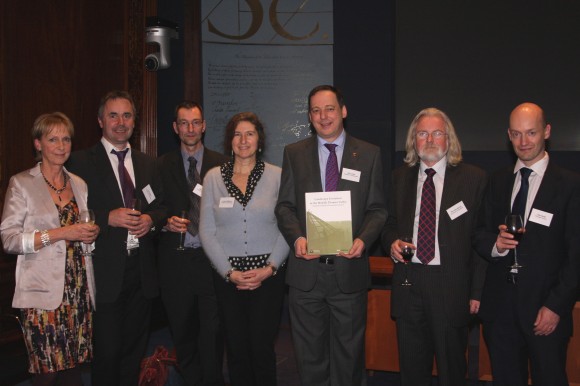
Say "cheese"!

Folk mingling at the book launch
Bronze Age settlement animation
Download an animation showing the Bronze Age settlement (requires QuickTime).
©BAA 2003
Produced by Marshall Lightfoot plc
Reproduced by kind permission BAA
2002-2008 Heathrow Terminal 5
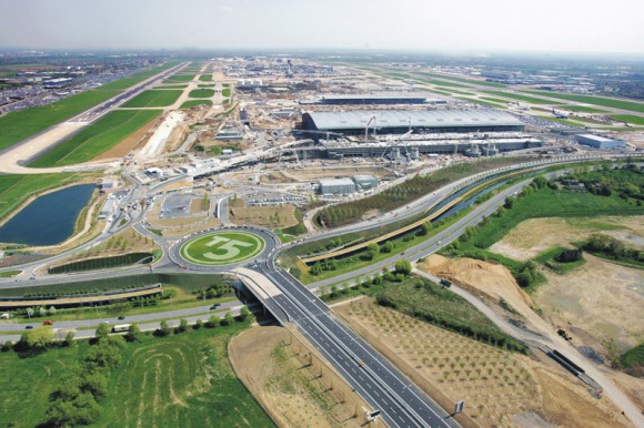
© BAA Limited see www.baa.com/photolibrary
![]()
The T5 site, while situated within the airport’s existing boundary, had previously been occupied by Thames Water’s Perry Oaks sludge works. Covering an area of around 260 hectares, it is equivalent in size to London’s Hyde Park and situated between two of the world’s busiest runways. Prior to construction the site was excavated by a team of over 90 archaeologists revealing that the land was occupied as far back as 6500 BC.
Construction began in earnest in the summer of 2002 and the terminal opened in 2008. BAA’s £4.2 billion investment is designed to cater for up to 35 million passengers annually and provides much needed terminal and airfield capacity to ease congestion and enable Heathrow to maximise use of its existing runways. On completion, British Airways transferred its entire operation, which use to be split between Terminals 1 and 4, to T5. As a result BAA is now able to address the investment and refurbishment needs of the four remaining terminals and complete the transformation of Heathrow.
T5 was one of Europe’s largest construction projects. With 16 major projects and over 147 sub-projects, it encompassed a vast and hugely complex programme of works. It remains a template for major construction projects of the future, pushing the boundaries of traditional construction, harnessing innovation and best practice from other industries and translating it into mainstream construction management.
In addition to the main terminal building, T5 also consists of two satellite buildings, 60 aircraft stands, a new air traffic control tower, a 4,000 space multi-storey car park, the creation of a new spur road from the M25, a 600-bed hotel, the diversion of two rivers and over 13km of bored tunnel, including extensions to the Heathrow Express and Piccadilly Line services.
This work encompassed a multitude of construction-related skills including Civil Engineering, Building, Highway Engineering, Mechanical & Electrical Engineering, Tunnelling, Railway Engineering, Specialist Systems Technology and Project Logistics management.
Memories of Perry Oaks
Nick Cooke (Project Officer at Heathrow 1998 – 1999)
There were a lot of unknowns when I first started working at Heathrow. It was the first time Wessex Archaeology and Oxford Archaeology had worked on a joint venture in the field, the recording system was entirely new and relied heavily on bespoke technology which had not been trialled in the field on such a scale. Initially we didn’t even know whether any archaeology would have survived the damage caused by the sludge beds of the sewage works.
I arrived on the site in the autumn of 1998 in charge of a small team whose job it was to find out whether any archaeology had survived. This involved watching mechanical diggers remove the remains of the treated sewage from the sludge beds. Pretty soon, it was clear that substantial quantities of archaeology lay beneath the sewage, and a winter of standing ankle deep in ‘cake’, as it was euphemistically called, lay ahead of us. Our small team began the task of surveying the extents of the archaeological features using Total Stations (although an attempt at using a robotic total station was abandoned after we found that it tended to track passing jumbo jets rather than the staff held by the surveyor!). By the end of the winter we had cleared over 20 hectares of land and surveyed the archaeological features in great detail. Despite several washes, I was unable to remove the smell of sewage and aircraft fumes from my working clothes, and had to throw them away.
We started the excavation proper early the following spring. The core team of supervisors, finds and environmental specialists and computer officers were on site early, setting up the offices (no mean feat when dealing with a team of over 70) and making all the necessary preparations. Time was well spent in team building and trialling the new recording system before the massive influx of diggers arrived. There was much emphasis on training the site staff in the early days, both in how to use the recording system and in how the on-site database and GIS system worked. One of the main aims of the recording system was to place much greater emphasis on the diggers to interpret the archaeology as well as record it objectively, and they embraced the opportunity enthusiastically.
The excavations lasted for nearly seven months and involved over 100 staff. Even small tasks which you take for granted on a small project became issues which needed addressing. We had to find accommodation for all of the staff, and provide transport to and from site – no mean feat in West London. Fortunately the team of project officers and supervisors coped magnificently, and all went well. We excavated a huge number of archaeological features, and found some lovely artefacts. Features ranging from Neolithic cursus and henge monuments to a post-medieval canal were carefully dug and recorded, whilst the nicer finds included polished Neolithic stone axes, a superb assemblage of worked wood from Middle Bronze Age waterholes, a pair of lovely carinated Late Bronze Age/Early Iron Age pots, and a hacked up piece of a lead tank or font from a late Roman pit. The combination of the new recording system and the use of on-site databases and GIS went very well, and we produced an unparalleled digital and paper archive of which everyone involved can be rightly proud.
When I look back on it now, though, it is the people who worked there who stay longest in my memory – for their hard work, professionalism and skill, but also for their laughter, sorrow, stubbornness, kindness, stroppiness, helpfulness and occasionally their sheer lunacy. You cannot work on a site for so long with so many people, sharing not only their working day but also their evenings and social lives without forging strong bonds. So when I look back, I also remember the barbecues, the solar eclipse, the parties (one a memorable night on a boat on the River Thames), the arguments, the mad games of park football, and the friendships that were formed. When I look back now at the thousands of photos we took during the course of the project, it is the faces I find myself looking for, and the people that I remember. The archaeologist in me will always remember the excavations and the finds, but it was the people with whom I worked who made it special.
Favourite photos
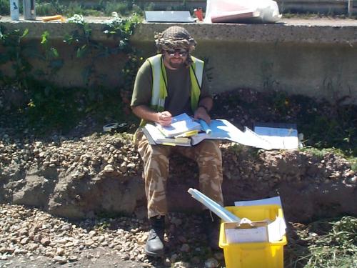
Rich Connolly, one of the supervisors, checking context sheets. We had a great team of supervisors, all in charge of small teams. Here you can see the tools of his trade – the box full of recording equipment, rolled up hand drawings and folders of completed context sheets. In the summer, the heat was a real problem, with Heathrow consistently amongst the hottest places in the country, hence the head gear, the sun lotion and the water bottle.
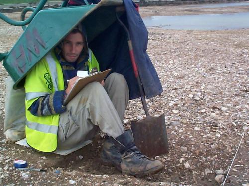
Steve Leech, one of the diggers taking shelter from inclement weather whilst recording a feature. Work continued in pretty much all weathers, although severe rain did on occasion cause the site to flood completely
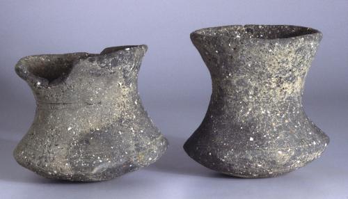
Late Bronze Age/Early Iron Age beakers. These were found placed at the bottom of a waterhole with a larger pot, presumably as part of an offering. I find them such tactile and stylish objects. They are also incredibly unusual – only one other similar vessel has been found from the River Thames. They date to the Late Bronze Age/Early Iron Age transition.
1066-1499 Medieval Manors
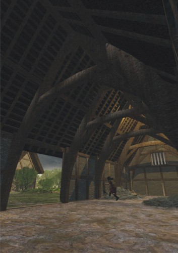
Interior of the medieval barn.
Manors to the south and west of London sold pigs, geese and chickens to the London market, and sometimes luxury items to richer customers. In 1293/4 and 1324 the Manor of Harmondsworth was keeping swans and peacocks.
Heathrow in the Medieval Period : c. 11th – 15th centuries
With the Norman invasion of 1066 the Saxon kingdom was conquered and a new social order imposed. The majority of agricultural land passed into the hands of the Norman elite who organised the landscape into estates and manors. The indigenous population became tenant farmers or bonded labour.
During the Terminal 5 excavations a relatively extensive medieval landscape was exposed including the remains of timber buildings, drainage ditches and boundary ditches found to contain medieval pottery. Many of the medieval ditches were recut along the same alignment as the ditches of the Bronze Age field systems. This suggests that banks and hedges of the Bronze age were still in existence over 2,500 years after they were originally created.
We are fortunate that at Heathrow we have been able to enrich our archaeological evidence with historical research.
The medieval manor of Harmondsworth was held by the Abbey of St Catherine’s at Rouen from shortly after the Norman conquest until 1391. Throughout the medieval centuries the main manor of Stanwell was held by the descendants of William fitz Other, who took the surname of Windsor because of their office of Constable of Windsor Castle. Most of the Windsor family probably lived at Stanwell in a manor house on the site of the later Stanwell Place to the west of the village. The impact of the Norman conquest on the area resulted in the inclusion of several manors in a castle-guard system attached to Windsor Castle. Stanwell manor was held from the Crown as half a knight’s fee and owed 16sh 8d to Windsor every 40 days for castle guard.
The largest holding in each manor was the lord’s demesne or home farm, consisting of arable land in the open fields, meadows in the Colne valley and pasture on Hounslow Heath and elsewhere. The villein tenants of the manors had holdings which each consisted of a series of cultivated strips in the common fields, allotted doles of meadow land and rights to pasture, in return for services performed for the lord of the manor on his demesne lands. They appear in rentals and conveyances of the 13th to 16th centuries at Harmondsworth and Stanwell holding virgates of about 30 acres, or half-virgates, or smaller landholdings around cottages. In Harmondsworth there was a great deal of sub-division and sub-letting of tenant holdings. Tenants paid a fine called a heriot to the lord when they inherited their holdings, normally consisting of their “best beast”. At Harmondsworth when the tenants had no animals, they sometimes paid in clothing, tools or furniture.
Almost all the arable land in Stanwell and Harmondsworth lay in open fields divided into cultivation strips or selions, which occupied a large percentage of both parishes. Strips of both demesne and tenant land were intermingled in the fields of both manors, grouped in numerous furlongs. In the 17th century the tenants of the open field land at Stanwell met at one of the village inns on four staking days each year to make the division of the strips. The ridge and furrow strips excavated in the T5 project lay in Longford Field in the manor of Harmondsworth. In 1404 tenants were fined in the Harmondsworth manor court for removing hedges and allowing their animals to enter the lord’s meadows and corn.
Manorial accounts show what crops were grown on the demesne land in particular years. Since the demesne arable strips were mostly intermingled in the common fields with the strips of the free and bond tenants, they must also have grown the same crops in similar proportions. Relatively little attention was paid in medieval agriculture to weeding crops, and environmental samples of plant remains from medieval sites normally contain a rich weed flora.
Between 1250 and 1350 demesnes in the Thames valley grew rye as the dominant crop, followed by barley, oats and wheat in that order of importance. Harmondsworth in 1293/4 was growing more wheat and oats than other crops, and wheat was accelerating in importance. Raising a variety of crops gave insurance against the failure of a particular crop in any one season. As barley and oats were normally sown in spring, and wheat and rye in autumn, the work of ploughing, manuring and sowing was spread more evenly over the year. This made the utilisation of tenants’ services and the rotation of crops easier. The leguminous crops of peas and vetch were cultivated extensively in England from the 13th century onwards to replace nitrates in exhausted soils, suppress weed growth and improve fodder supplies. Only a small portion of the demesne land was left fallow in each year.
Manuring fallow fields by folding sheep on them was an integral part of the open field system of agriculture, the sheep acting as mobile muckspreaders within moveable folds made from hazel hurdles. The sheep of whole villages were controlled in this operation by communal shepherds. Dung cart and dung forks formed part of Harmondsworth manor’s equipment in the 15th century; muck and rubbish from the manor courtyard was spread on the fields as part of the services owed by the tenants.
The Domesday Book survey implies that teams of oxen were used to draw ploughs in the 11th century, the demesne teams using eight oxen, the tenants ploughing with smaller teams. In the 12th and 13th centuries work horses called stots or affers replaced oxen as the main draught animals in Middlesex. Manors to the south and west of London sold pigs, geese and chickens to the London market, and sometimes luxury items to richer customers. In 1293/4 and 1324 Harmondsworth was keeping swans and peacocks.
It was necessary to move much of this stock around from common grazing to enclosed pasture fields to fallow grazing on the stubble after the harvest. Small greens and grazing areas were linked by a network of hedged lanes and wider driftways. In Stanwell the linked grazing areas of Farther Moor, Hither Moor, Spout Moor and Borough Green formed a stock movement route from the meadow lands of the Colne valley, between the open arable fields of the manor and the enclosed fields of its northern edge, to the pasture lands of Hounslow Heath. The excavations discerned patterns of ditches near Borough Green which could be interpreted as stock funnels.
410-1066 AD A New Beginning
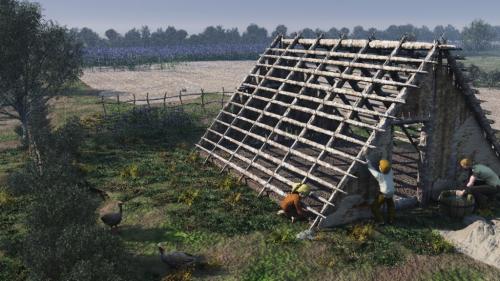
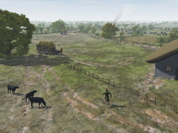
A Saxon family work on the construction of a building. Flax fields are visible beyond.
Following Britain’s exit from the contracting Roman Empire, the towns and cities, which had already been in decline during the later part of the Roman period, rapidly fell into disuse. Severed from the wider network of the Roman Empire the focus appears to return to the local scale and immediate landscape. However, processes were at work, which led to the emergence of Saxon society. At Heathrow a dispersed, drifting pattern of settlement seems once again to emerge, set within a sparsely occupied land. Excavations south of the medieval and present day village of Longford revealed a settlement of sunken-featured buildings, pits and postholes dating to the 6-7th century AD. People continued to cultivate the land, and also seem to have grown flax to provide linen and oil. Despite the dearth of evidence from the current excavations for the Middle Saxon period, the region in general saw the emergence of more stable settlement locations at this time, with increasing nucleation in the late Saxon period leading to the familiar pattern of villages and open fields. It seems likely that the excavated Saxon settlement eventually developed into the medieval village of Longford that we see today.
The Post-medieval period, 1500 – 1937
Many of the Bronze Age field boundaries found at Heathrow were still in use during the Medieval period. Some even persist as property boundaries on the Estate map of 1748.
Two of the most prominent features of the Heathrow landscape were constructed in the 16th and 17th centuries. The Duke of Northumberland’s River was diverted in 1543 to increase the water supply to Isleworth Mill, and in the 17th century (during the reign of Charles I) the Longford River was constructed to improve the water supply to Hampton Court. Both these rivers were diverted as part of the Terminal 5 construction project.
During the 18th century large parts of the medieval landscape at Heathrow were enclosed by acts of Parliament. However, many of the medieval (and hence originally Bronze Age field boundaries continued in use into particularly in the western part of the site. Similarly many post medieval boundaries such as the parish boundary and Long Lane show a good fit with medieval land divisions. In the 19th and early 20th centuries Heathrow was noted as an important market gardening area. The reason for this was that the brickearth soils of the Heathrow area were very fertile, and their productivity was enhanced by vast quantities of horse manure from the huge numbers of horses required for transport in and around London. Fruit growing was also prevalent: indeed prior to the construction of the Perry Oaks sludge works in 1934, the site was occupied by an orchard.
Posted in Uncategorized
Leave a comment
John Lewis on the moment he realised the Stanwell cursus was a political statement
Everyone’s invited to the Neolithic party
On a personal level, my most enduring feeling is one of gratitude for the hard work of so many people over such a long time on this project. Hundreds of archaeologists have now worked on the various elements of the T5 project, and they have all contributed to producing a level of understanding of the history of the Heathrow area that I could only dream about when I started my archaeological career in west London in 1984. I also have to say that the BAA team and their archaeological consultants, Gill Andrews and Professor John Barrett have played a huge part in shaping not only the project but also the ethos of Framework Archaeology.
In archaeological terms, my favourite discovery was working out what the Stanwell cursus near Heathrow actually looked like in the Neolithic period – and what this meant about the nature of society in the area.
The discovery came about during rescue excavations on Thames Water’s sludge works at Perry Oaks. This charming spot was where London’s processed sewage has been pumped since the 1930s onto vast gravel beds to dry before being turned into organic agricultural fertiliser. New technology has now condensed that operation, so most of the site was being cleared.
Initially I worked as a project manager for MoLAS (the Museum of London Archaeology Service) during the first season’s excavations in 1996, and later came back to dig the site more thoroughly for Framework Archaeology in 1998-99. It was a colossal site, of which we excavated about 60 acres (25 ha) during this phase. Just walking around the site took most of the day. We also had to shout a lot because of the Heathrow aircraft constantly flying overhead.
Ancient landscape
But it was an amazing excavation because beneath all these acres of drying beds we found a fantastic landscape dating from the Mesolithic through to the end of the Roman period. But the major monument was the Stanwell cursus, which is at least 2.5 miles long and is the second longest in the country (after the Dorset cursus). The site had been known for some time from aerial photographs and earlier excavations. On our site it appeared as two parallel ditch-lines in the ground.
However the ditches were only about 22m apart – making it about three or four times narrower than a normal cursus. So what did it look like originally, and how was it used? Did it have the normal pair of banks flanking a processional pathway, or was it just a single bank between the two ditches?
I had the plan of the cursus on my wall, showing how it was crossed by a network of Bronze Age field ditches. And as I stared at it, and thought about it, I noticed that one of these ditches narrowed as it began to cross the cursus, and opened out again when it emerged from the other side, in a sort of ‘hourglass’ shape. This was really puzzling until I suddenly realised that the Bronze Age farmers in 1500 BC must have dug their ditch right over the top of the still-existing cursus bank.
Although they maintained the relative depth of their ditch, it didn’t penetrate as deeply into the ground as it crossed the bank. Later, as we looked at other Bronze Age ditches crossing the cursus we found the same ‘hourglass’ pattern again and again. The result of all this was to show that the cursus had always been a single, banked-up pathway between ditches – in other words not really a cursus at all, more a ceremonial causeway or dyke.
I was really excited about this because of what it suggested about Neolithic society in the area. Generally cursuses are interpreted as formalised ceremonial paths from one important place to another. Before they were built, the processions took place on an ordinary pathway, with whole communities able to take part – perhaps meeting at certain points, singing, dancing, drinking, breaking a few pieces of pottery, or knapping a piece of flint.
Exclusive ceremonies
Then as time went on the ceremonies became more exclusive. Typical cursuses, like the Dorset cursus in Wessex, were built on the route of the ceremonial path with high flanking banks to prevent outsiders seeing what was going on within. In many areas, this social stratification increased in the Bronze Age with the elite buried in single tombs with all their finery.
But the west London area seems to be different. There were ceremonial processions in the landscape, and one of these pathways was formalised into the Stanwell cursus. But instead of two flanking ditches you have a raised path. Instead of secret ceremonies, you have processions that were designed to be seen. Then in the Bronze Age, there is no sign of the social differentiation that you get in Wessex. There are no large henges, and virtually no rich burials. It all fits together. The Early Bronze Age of the west London area was not occupied by an overtly stratified and exclusive society – and I believe this reflects the sort of community that a few hundred years earlier built the Stanwell cursus with its ‘socially inclusive’ raised central bank.
Adapted from an article first published in issue 65 of British Archaeology Magazine in June 2003
1934 – 2002 The Perry Oaks Sludge Works
One of the earliest phases of the archaeological work at T5 was the recording and interpretation of the disused sludge works at Perry Oaks. Built in the 1930’s the development of the plant is testament to the unprecedented population growth seen in the late 20th century.
When the plant was constructed in 1934 it was the equal of any of the most advanced plants found in Germany and the USA. By the time of its demolition in 2002 the plant had undergone a series of changes reflecting the development of waste treatment techniques.
The early circular concrete tanks were supplemented in 1952 with large rectangular tanks and later by a series of lagoons. The introduction of centrifuges in the late 1990’s eventually made such features redundant.
In 1965 the manual process of emptying the 72 acre drying beds was mechanised by the installation of mobile shovels and a traveling elevator.
The site also saw changes in the way that sludge was transported. In 1937 a portable 2ft gauge railway was in use on the beds. Dried sewage “cake” was, until 1940, dumped on site but the shortages during WWII created a demand for the material as an agricultural fertilizer. By the 1960s a special dried sludge storage area had been constructed. This was augmented by the installation of a conveyor system in 1965 but again both were made obsolete by the introduction of centrifuges able to discharge directly into parked trailer units.
Both the construction and operation of these works were described in detail in Institution of Civil Engineers papers 5120 and 5599.

